
If you have only one week and want to see and experience as much as possible with your own or chartered yacht in these seven days, the D Marin Marina Mandalina in Šibenik on the central Adriatic in northern Dalmatia is just the right starting point. From here, you can either sail west to explore the Kornati National Park (Part 1 of our sailing trip tip) or head north – in freshwater – up the Krka to Lake Prokljansko and take a trip to the Krka waterfalls.
Hardly any other area offers such a great variety in such a small space as the Middle Adriatic in the north of Dalmatia with Šibenik and the many smaller and larger offshore islands. From here it is only a stone’s throw to the Kornati National Park in the southwest or in a WNW direction along the coast to Biograd (see “Trip Tip Part 1, Kornati: One Week from Šibenik with Your Own Yacht” and “Croatia by Yacht: Trip Tip Zadar“).
Alternatively, however, the crew can also explore the national park of the same name and the waterfalls located to the northeast on their own keel, sailing up the Krka from Šibenik. There is also much to discover in this (freshwater) area, and several marinas offer their services here, which can also be used as a good starting point for an Adriatic cruise.
Day 1: Mandalina / Šibenik – Zaton – Raslina – Prokljansko Lake – ACI Marina Skradin
Those who start their cruise in D Marina Mandalina, as we did, should allow time for sightseeing in Šibenik. The town, which is located not far from the mouth of the river Krka into the Adriatic Sea at a naturally protected harbor, is separated from the sea only by an approximately 2.5-kilometer-long natural breakthrough, the so-called Antonius Channel (Sv. Ante). Two national parks can be explored from Šibenik: Kornati and Krka.
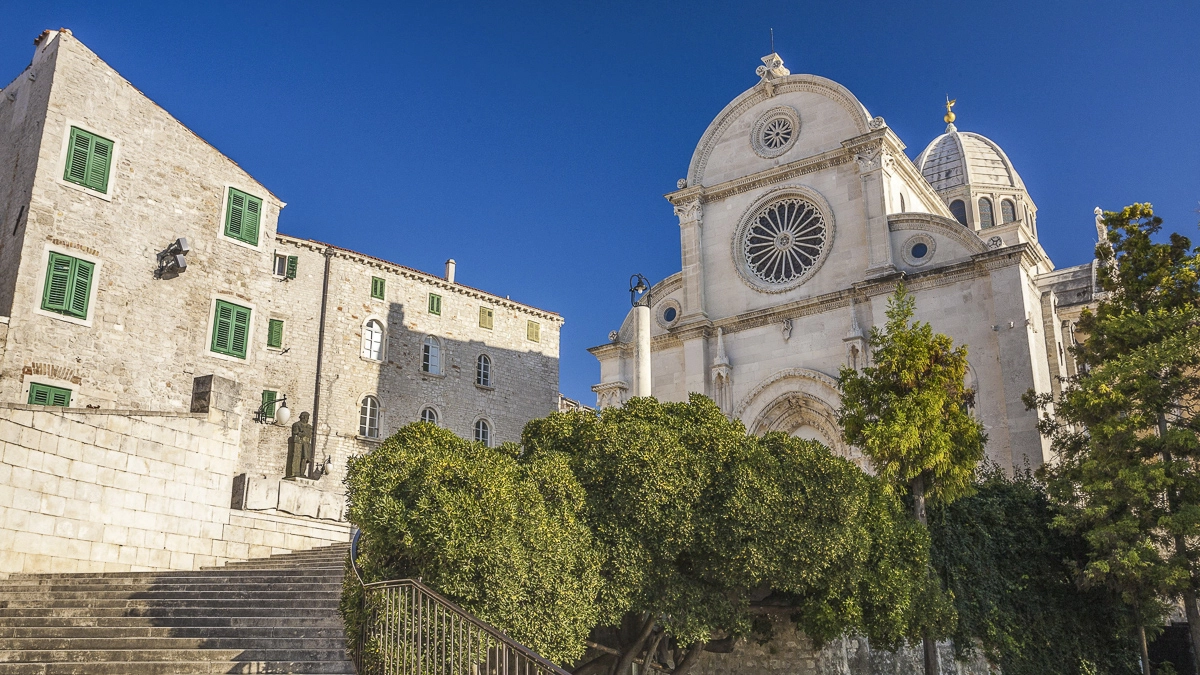
The most important building in Šibenik, which is also called the city of stairs because of its 2,800 steps, is the Cathedral of St. Jacob (Katedrala sv. Jakova), whose roof consists of a barrel vault made of cantilevered stone slabs. The cathedral is included in the UNESCO World Heritage List.

Mit dem Laden des Videos akzeptieren Sie die Datenschutzerklärung von YouTube.
Mehr erfahren
From Marina D-Marin Mandalina we head northwest along the Krka.
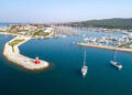
On the first day, we leave the marina D-Marin Mandalina, Croatia’s only marina designed for superyachts and awarded by the prestigious Yacht Harbour Association of London, not heading west like many other yachts, but passing the port side channel of Sv. Ante leading to the sea on starboard and staying on course northwest; on starboard side the city port of Šibenik runs astern.
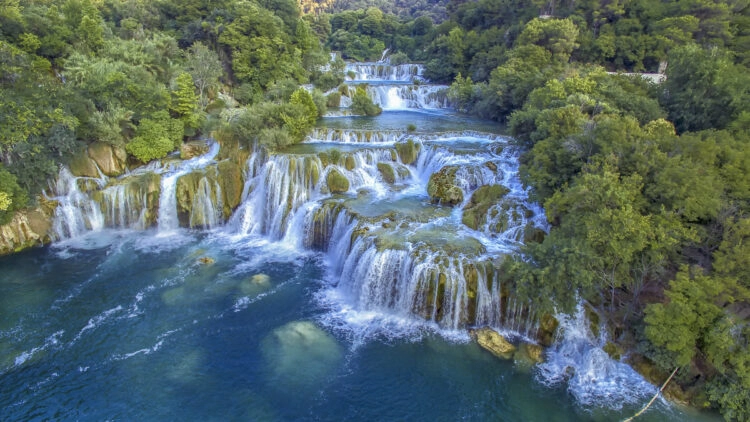
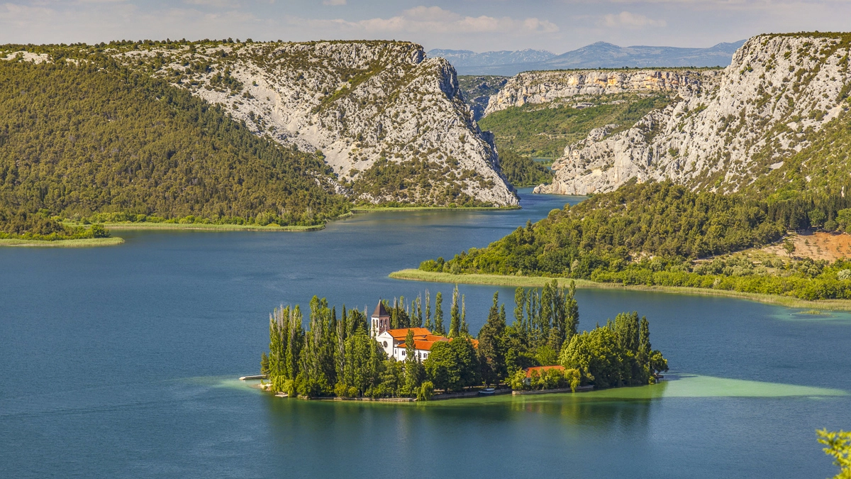
We sail upstream on the Krka River, which widens like a reef in front of Šibenik, because we want to visit first the Prokljansko Lake and finally the picturesque Krka Waterfalls (cover picture) in the next two days, on a “freshwater course”.
After about half an hour’s drive, a bridge spans the Krka, over which runs the car road that connects Šibenik with the town of Zaton in the northwest. But don’t worry, the bridge height is at least 27 meters, which should be sufficient for most charter (sailing) yachts.
There is a right-hand drive on the Krka, and there is a speed limit.
Caution, should the crew be traveling with a chartered motor yacht: you should not be tempted by the smooth river water to go too fast, because the maximum speed allowed on the Krka, which is open to navigation until Skradin, is only five knots! The reason for this is, among other things, the mussel farms that are operated on the river banks, for which calm water is a prerequisite. In addition, there is a right-hand traffic rule everywhere.
After the bridge passage, the river branches off to the northeast on the starboard side; however, we initially continue straight ahead and only a short time later reach Marina Zaton, which is located on the port side. One should not be surprised: Zaton means bay in German, so there are several marina designations in Croatia that bear this name (e.g., a marina north of Zadar, one near Dubrovnik, or a small municipal harbor a bit NW of our current location).
From the restaurant of Marina Zaton you have a good view of the bay.
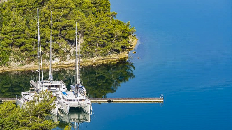
At “our” Marina Zaton on Krka is a small, quiet marina consisting of just two shore quays on either side of a marina building. There are mooring lines, electricity and water at the jetty, a store, sanitary buildings and a restaurant on the second floor of the marina building, from which there is a beautiful view of the bay. In addition, a charter company has its base here.
At this point, we will not go into detail about the municipal harbor of Zaton, which is located a short distance to the northwest, because the water depth at the concrete quays, which extend around the inside of the bay, is very shallow. However, if you want, you can take a walk from the marina to the quiet vacation resort, where there are restaurants in the harbor as well as two stores. If you still want to go to Zaton on your own keel, it is best to moor in front of the northern shore near the restaurant at a water depth of about 2.5 meters (few moorings with mooring lines).
The Prokljansko lake is about three times a nautical mile in size, the only place on the western shore is invites Raslina, in the south of the lake is Bilice
We leave the marina Zaton again to the southeast and after a short stretch we turn to port. We follow the now strongly meandering but well buoyed Krka to the northeast and after a short passage with great views we reach the Prokliansk Jezero (Jezero means lake), a body of water about three nautical miles long (from north to south) and one nautical mile wide.
Keeping to port, we round the shallow buoy east and make a short detour to Raslina on the west shore. The place makes a very quiet and relaxed impression, only on the east breakwater of the small bay there are a couple of mooring moorings, and guests can also moor at the head of the breakwater, but caution is advised as the water depth is less than two meters. There is no electricity or water at the jetty, only the small restaurant Dalmatino invites you to visit.
In Bilice there are restaurants and a supermarket, a new marina is being built
In the south of the lake, the small village of Bilice is also inviting, here, in addition to the two restaurants Panova and Oldi and the five cafes/bars Plaza Sparadici, Stubalj, Plaza Mikulandre, St. Tropez and Solist, there is also an opportunity to replenish supplies in a small supermarket. Currently, a new marina is being built in Bilice with 150 berths. There are also plans for an 18-hole golf course not far from the village, with upscale restaurants and a five-star hotel attached.
Those who want to sail the lake should be aware of two shoals in the northern and northeastern parts; however, these are not shown in the common Sea maps well charted.
Shortly before the highway bridge, the Smokvic and Vidrovaca restaurants beckon to starboard
We cross Lake Proklljanso from west to east, pass a shallow buoy south on the lake shore near the entrance to the Krka branching off to the east, and follow the course of the river. About 300 meters before the highway bridge, on the starboard side, the restaurant Smokvic (with some berths) and about 250 meters further on the restaurant Vidrovaca invite you to visit them.
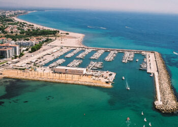
Just behind the highway bridge, on the port side, is the ACI Marina Skradin, which stretches to the left and right of a small bay. The marina, which is about ten nautical miles from Šibenik (about two hours for a non-stop trip), offers the usual service; 153 berths are available, but not always enough in the high season.
This could become a problem, because anchoring is (officially) not allowed outside the marina. We look for a (quieter) mooring place on a pier facing away from the city side, all berths are equipped with water and electricity, there is WLAN and several restaurants.
Mit dem Laden des Videos akzeptieren Sie die Datenschutzerklärung von YouTube.
Mehr erfahren
Day 2: Krka – National Park exploration, on foot, by bike or transfer boat
Skradin is a typical tourist town, but the place is perfect to spend a full day (or longer) from here exploring the Krka National Park, established in 1985. This covers an area of 109.5 square kilometers, spread over the approximately 45 kilometer long stretch of the Krka River between Knin and Skradin, as well as the lower reaches of the tributary Čikola. The national park represents an important biotope, there are about 860 plant and 220 animal species in it.
Those who wish to visit the impressive Krka waterfalls at Skradinski buk can do so in several ways: either use one of the transfer boats from the outer bay of Skradin for the round trip (the fare is included in the park entrance fee), or rent a bicycle in town for the approximately four-kilometer route and start pedaling.
The most beautiful way to explore Krka National Park is to hike it.
However, the most beautiful way to explore the nature park is to hike it. Here you can enjoy the varied river landscape in peace, mostly undisturbed by the hustle and bustle. An approximately two-kilometer-long nature trail has been established, which leads over solid planks and a few bridges to particularly beautiful vantage points or to restored mills, where it is illustrated how people used to work and live here.
If you want, you can explore castle ruins from the 14th century further upriver, more waterfalls (though not as spectacular as at Skradinski buk) or an island monastery (by boat) – or you can turn back from here and let one of the transfer boats take you back to the marina. From there, you should plan a day for the leisurely return to Šibenik, but then with the current, which here can be between 0.5 and 1.5 knots.
Interactive cruise map
Mit dem Laden der Karte akzeptieren Sie die Datenschutzerklärung von Google.
Mehr erfahren
Tip from the SeaHelp editors:
For the described trip, many drone photos and 360 degree images are available on our SeaHelp app, so you can already look at many bays in advance and plan your trip perfectly.
Download SeaHelp app: